Právě vyšlo - naše nejnovější studie
Přehled aktuálních odborných článků na kterých se podíleli členové a studenti Katedry fyzické geografie a geoekologie PřF UK.
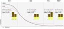
Vargas Godoy, M. R., Markonis, Y., Rakovec, O., Jenicek, M., Dutta, R., Pradhan, R. K., Bešťáková, Z., Kyselý, J., Juras, R., Papalexiou, S. M., and Hanel, M. (2024): Water cycle changes in Czechia: a multi-source water budget perspective, Hydrol. Earth Syst. Sci., 28, 1–19. https://doi.org/10.5194/hess-28-1-2024.
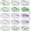 The study introduces a novel benchmarking method based on the water cycle budget for hydroclimate data fusion. Using this method and multiple state-of-the-art datasets to assess the spatiotemporal patterns of water cycle changes in Czechia, we found that differences in water availability distribution are dominated by evapotranspiration. Furthermore, while the most significant temporal changes in Czechia occur during spring, the median spatial patterns stem from summer changes in the water cycle.
Garba, R., Usyk, V., Ylä-Mella, L. et al. East-to-west human dispersal into Europe 1.4 million years ago. Nature (2024). https://doi.org/10.1038/s41586-024-07151-3
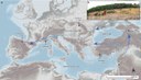 Stone tools stratified in alluvium and loess at Korolevo, western Ukraine, have been studied by several research groups since the discovery of the site in the 1970s. Although Korolevo’s importance to the European Palaeolithic is widely acknowledged, age constraints on the lowermost lithic artefacts have yet to be determined conclusively. Here, using two methods of burial dating with cosmogenic nuclides, we report ages of 1.42 ± 0.10 million years and 1.42 ± 0.28 million years for the sedimentary unit that contains Mode-1-type lithic artefacts. Korolevo represents, to our knowledge, the earliest securely dated hominin presence in Europe, and bridges the spatial and temporal gap between the Caucasus (around 1.85–1.78 million years ago) and southwestern Europe (around 1.2–1.1 million years ago). Our findings advance the hypothesis that Europe was colonized from the east, and our analysis of habitat suitability9 suggests that early hominins exploited warm interglacial periods to disperse into higher latitudes and relatively continental sites—such as Korolevo—well before the Middle Pleistocene Transition.
Nørgaard, J., Margold, M., Jansen, J. D., Kurbanov, R., Szuman, I., Andersen, J. L., et al. (2023). Absence of large-scale ice masses in central Northeast Siberia during the Late Pleistocene. Geophysical Research Letters, 50, e2023GL103594.
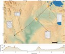 Ongoing speculation regarding the existence of large Late Pleistocene ice masses in Northeast Eurasia reflects the dearth of age constraints on glaciations across this vast region. Here, we report the first dates from the central part of Northeast Siberia, consisting of 22 cosmogenic 10Be exposure ages from boulders deriving from a sequence of three moraines in the Chersky Range. The dated moraine sequence indicates progressive contraction of maximum glacier extent from Marine Isotope Stage 6 to the Last Glacial Maximum, while the remotely-sensed mapping indicates an older, more expansive glaciation in the region yet undated. Our results show that Late Pleistocene glaciations were limited to the highlands, and Northeast Siberia did not host a large, coalescent ice sheet during the Last Glacial Maximum or Marine Isotope Stage 6.
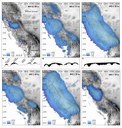
Hotovy, O., Nedelcev, O., Jenicek, M. (2023). Changes in rain-on-snow events in mountain catchments in the rain-snow transition zone. Hydrological Sciences Journal, 68(4), 572-584.
 A shift from snowfall to rain affecting snow storage is expected in future. Consequently, changes in rain-on-snow (ROS) events may occur. We evaluated the frequency and trends in ROS events and their runoff responses at different elevations related to changes in climate variables. We selected 40 central European mountain catchments located in the rain–snow transition zone, and used a conceptual catchment model to simulate runoff components for the period 1965–2019. The results showed large temporal and spatial differences in ROS events and their respective runoff responses across individual study catchments and elevations, with primarily an ROS increase at highest elevations and a decrease at lower elevations during spring. ROS events contributed 3–32% to the total seasonal direct runoff. The detected trends reflect changes in climate and snow variables, with an increase in air temperature resulting in the decrease in snowfall fraction and shorter snow cover period.
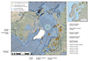
Helen E. Dulfer, Benjamin J. Stoker, Martin Margold & Chris R. Stokes (2023). Glacial geomorphology of the northwest Laurentide Ice Sheet on the northern Interior Plains and western Canadian Shield, Canada, Journal of Maps, DOI: 10.1080/17445647.2023.2181714
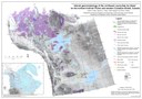 The majority of the Northwest Territories of mainland Canada was covered by the Laurentide Ice Sheet during the Last Glacial Maximum. The increasing coverage of high-resolution remotely sensed data provides new opportunities to map the glacial geomorphology and study the glacial history of this remote location. Here we present a comprehensive map of glacial landforms within the northern Interior Plains and adjacent areas of the Canadian Shield, comprising around 6% of the Laurentide Ice Sheet bed. Twelve landform types were mapped from the high-resolution ArcticDEM which provides a record of the highly dynamic behaviour of the northwest sector of the Laurentide Ice Sheet.
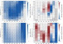
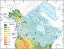
Tumajer, J., Begović, K., Čada, V., Jenicek, M., Lange, J., Mašek, J., Kaczka, R. J., Rydval, M., Svoboda, M., Vlček, L., Treml, V. (2022). Ecological and methodological drivers of non- stationarity in tree growth response to climate. Global Change Biology, 29(2), 462-476.
 Radial tree growth is sensitive to environmental conditions, making observed growth increments an important indicator of climate change effects on forest growth. To systematically assess potential drivers of non-stationarity, we compiled tree-ring width chronologies of two conifer species, Picea abies and Pinus sylvestris, distributed across cold, dry, and mixed climates. We analyzed 147 sites across the Europe. We calibrated four numerical models to simulate growth chronologies based on temperature and soil moisture data. The degree of non-stationarity varied between species, site climatic conditions, and models. We conclude that non-stationarity in climate–growth responses is a multifactorial phenomenon driven by the interaction of site climatic conditions, tree species, and methodological features of the modeling approach. We recommend that temporal non-stationarity rather than stationarity should be considered as the baseline model of climate–growth response for temperate forests.
Young, J. M., Alvarez, A., van der Sluijs, J., Kokelj, S. V., Rudy, A., McPhee, A., Stoker, B. J., Margold, M., Froese, D. (2022). Recent intensification (2004–2020) of permafrost mass-wasting in the central Mackenzie Valley foothills is a legacy of past forest fire disturbances. Geophysical Research Letters, 49, e2022GL100559.
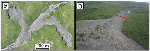 The effects of recent climate change are accelerating permafrost thaw, including ice-rich landscapes of the western Canadian Arctic. However, regional drivers of permafrost slope failure in hillslopes with warm, thin permafrost remain poorly understood. We characterize the type and nature of permafrost slope failures in the central Mackenzie Valley, NWT and find hillslope failures have increased rapidly over the past ∼15 years. This growth occurred in conjunction with increasing air temperatures and summer precipitation but the distribution of permafrost slope failures in this area is largely constrained by forest fire extents that affected the area in the 1990s. These fires have led to increased landscape sensitivity of this ice-rich terrain through their impacts on ground temperatures.
Stoker, B. J., Margold, M., Gosse, J. C., Hidy, A. J., Monteath, A. J., Young, J. M., Gandy, N., Gregoire, L. J., Norris, S. L., and Froese, D. (2022). The collapse of the Cordilleran–Laurentide ice saddle and early opening of the Mackenzie Valley, Northwest Territories, Canada, constrained by 10Be exposure dating, The Cryosphere, 16, 4865–4886.
 The Laurentide Ice Sheet was the largest ice sheet to grow and disappear in the Northern Hemisphere during the last glaciation. In northwestern Canada, it covered the Mackenzie Valley, blocking the migration of fauna and early humans between North America and Beringia and altering the drainage systems. We reconstruct the timing of ice sheet retreat in this region and the implications for the migration of early humans into North America, the drainage of glacial lakes, and past sea level rise.
Juřicová, A., Chuman, T., & Žížala, D. (2022). Soil organic carbon content and stock change after half a century of intensive cultivation in a chernozem area. Catena, 211, 105950.
 Soil organic carbon (SOC) is a sensitive and substantial soil component controlling soil quality with a direct impact on global food security. Assessment of long-term changes in SOC content and stocks allows for quantifying the effect of soil redistribution and supports to understand of carbon cycling. We detected the regional SOC content and stocks change by re-sampling soil profiles from the 1960s on arable land in the dynamic environment of the chernozem region. Surprisingly, the change in SOC content tends to be positive after more than 50 years. Increasing content of clay particles' is found to be a dominant factor in the shift in SOC content through its binding with SOC in organo-mineral complexes. Moreover, the results show remarkable SOC stocks change, especially for sites the most influenced by soil redistribution. We concluded that soil erosion is a dominant process in our study area, explaining the long-term changes in SOC stocks.
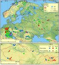
Dalton, A. S., Gowan, E. J., Mangerud, J., Möller, P., Lunkka, J. P., and Astakhov, V. (2022). Last interglacial sea-level proxies in the glaciated Northern Hemisphere, Earth Syst. Sci. Data, 14, 1447–1492
 Because global sea level during the last interglacial (LIG; 130–115 ka) was higher than today, the LIG is a useful approximate analogue for improving predictions of future sea-level rise. Here, we synthesize sea-level proxies for the LIG in the glaciated Northern Hemisphere for inclusion in the World Atlas of Last Interglacial Shorelines (WALIS) database. We describe 82 sites from Russia, northern Europe, Greenland and North America from a variety of settings, including boreholes, riverbank exposures and along coastal cliffs. The database is available at https://doi.org/10.5281/zenodo.5602212.
April S. Dalton, Tamara Pico, Evan J. Gowan, John J. Clague, Steven L. Forman, Isabelle McMartin, Pertti Sarala, Karin F. Helmens (2022). The marine δ18O record overestimates continental ice volume during Marine Isotope Stage 3, Global and Planetary Change, 212, 103814.
 There is disagreement in the Quaternary research community in how much of the marine δ18O signal is driven by change in ice volume. Here, we examine this topic by bringing together empirical and modelling work for Marine Isotope Stage 3 (MIS 3; 57 ka to 29 ka), a time when the marine δ18O record indicates moderate continental glaciation and a global mean sea level between −60 m and −90 m. We compile and interpret geological data dating to MIS 3 to constrain the extent of major Northern Hemisphere ice sheets (Eurasian, Laurentide, Cordilleran). Many key data, especially published in the past ~15 years, argue for an ice-free core of the formerly glaciated regions that is inconsistent with inferences from the marine δ18O record. We compile results from prior studies of glacial isostatic adjustment to show the volume of ice inferred from the marine δ18O record is unable to fit within the plausible footprint of Northern Hemisphere ice sheets during MIS 3. Instead, a global mean sea level between −30 m and − 50 m is inferred from geological constraints and glacial isostatic modelling. Our work urges caution regarding the reliance of the marine δ18O record as a de facto indicator of continental ice when few geological constraints are available, which underpins many Quaternary studies.
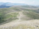
Helen E. Dulfer, Martin Margold, Christopher M. Darvill, Arjen P. Stroeven (2022). Reconstructing the advance and retreat dynamics of the central sector of the last Cordilleran Ice Sheet. Quaternary Science Reviews, 284, 107465
 The Cordilleran Ice Sheet (CIS) formed part of the North American Ice Sheet Complex at the Last Glacial Maximum and contained an ice volume similar to the present-day Greenland Ice Sheet. Here we use the glacial landform record of northern British Columbia to unravel the advance and retreat dynamics of the central sector of the CIS, beneath the LGM ice divide. We use flowset classification to unravel complex changes in ice flow direction over time and the distribution of ice-marginal landforms to determine the relative deglaciation pattern. We also show that a Late Glacial cooling event resulted in the regional growth of independent mountain glaciers, ice caps, and ice fields at high elevations followed by the readvance of CIS outlet glaciers along its eastern margin. This allows us to establish the ice sheet configuration during the Late Glacial period for the first time.
Fraindová, K., Matoušková, M., Kliment, Z., Vlček, L., Vlach, V., Springerova, P., (2022). Headwaters biogeochemistry focused on different rainfall-runoff conditions, and the role of waterlogged areas: a comparative study of Czech mountains. Hydrological Sciences Journal, 67(4), 588–612.
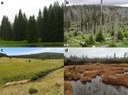 This study focuses on changes of biogeochemical parameters related to variable rainfall-runoff conditions and to land cover types for eight headwater catchments in Central Europe. The presence of peatbogs and waterlogged spruce forests had a decisive influence on the biogeochemistry (higher concentration of organic matter, humins, iron, phosphorus and nitrogen compounds). The strongest positive correlation of organic matter and iron is represented in a catchment with the largest area of damaged forest (70%), but with a smaller proportion of waterlogged areas (8%). High flow rates influence greater release of organic matter and nitrate nitrogen. The catchment with the highest (80%) peatbog cover and the catchment that had undergone revitalization showed similar behaviour in terms of water biogeochemistry. The type of rainfall-runoff event affected the velocity of pH changes, whereas the variability in electric conductivity was also controlled by the catchment characteristics and hydrological preconditions.
Fraindová, K., Matoušková, M., Kliment, Z., Vlach, V., (2022). Changes and dynamics of headwaters chemistry on the boundary of nature protected areas: Example of upper Blanice River catchment, Czechia. Geografie,127.
 Changes of biogeochemical parameters in the context of long-term trends and different rainfall-runoff conditions were examined with a special focus on various catchment characteristics. The study area is situated in the upper part of the Blanice River catchment, where more than 77% of the area belongs to a Protected Landscape Area and is unique for the most abundant population of the critically endangered freshwater pearl mussel (Margaritifera margaritifera) in Central Europe. A decrease of nitrogen and phosphorus compounds has been proven at the catchment outlet since 2003. The nine study catchments were divided into three main groups according to biogeochemical composition (natural, partly anthropogenically influenced, subsurface drainage). Changes of biogeochemical parameters during different runoff conditions revealed a higher release of aluminium, organic matter, dissolved organic carbon and total phosphorus during heavy precipitation event, which could have a negative effect on the vulnerable ecosystem including freshwater pearl mussel.
Dalton, A.S., Stokes, C.R., Batchelor, C.L. (2022). Evolution of the Laurentide and Innuitian ice sheets prior to the Last Glacial Maximum (115 ka to 25 ka). Earth-Science Reviews, 224. 103875.
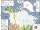 The Laurentide Ice Sheet was the largest global ice mass to grow and decay during the last glacial cycle (~115 ka to ~10 ka). Despite its importance for driving major changes in global mean sea level, long-term landscape evolution, and atmospheric circulation patterns, the history of the Laurentide (and neighbouring Innuitian) Ice Sheet is poorly constrained owing to sporadic preservation of stratigraphic records prior to the Last Glacial Maximum (~25 ka) and a case-study approach to the dating of available evidence. Here, we synthesize available geochronological data from the glaciated region, together with published stratigraphic and geomorphological data, as well as numerical modelling output, to derive 19 hypothesised reconstructions of the Laurentide and Innuitian ice sheets from 115 ka to 25 ka at 5-kyr intervals, with uncertainties quantified to include best, minimum, and maximum ice extent estimates at each time-step.
Publikováno:
Čtvrtek 21.03.2024 00:00
Akce dokumentů