About the Map Collection
“The Map Collection contains one of the largest and most important collections of maps in the Czech Republic. Many experts in the field of cartography have worked here, the foremost being Prof. Karel Kuchař. He and many other researchers here have contributed to the development of Czechoslovak and Czech cartography with their scientific works and publications. The present day Map Collection uses modern technology for study research work and public exhibits.” (Mgr. Peter Mackovčin, PhD.)
The Map Collection is a universal collection for science, research and education. It serves the academic employees and students of Charles University as well as the professional and lay public (see Map Collection Services).
“The uniqueness of the Map Collection lies in the long tradition of history of cartography at Charles University in conjunction with the founding of the collection, the uniqueness of maps and atlases stored there, and the incredible space housing the collection which has been preserved to the present and meticulously restored.” (prof. PhDr. Eva Semotanová, DrSc.)
There are 66,812 (as of July 26th, 2023) documents in the electronic catalog. Digitized maps from the TEMAP project are available from the Digital University Repository.
The Map Collection was established along with the CU Geographic Institute (1891). In 1913 it was moved to Albertov 6, Prague 2, where it has remained to this today in a unique historic interior. In 1920, the Faculty of Science was founded and with it the State Map Collection, as proposed by Prof. Václav Švambera. It obtained part of the military archive in Vienna and considerable financial subsidies for acquisitions. After the 2nd World War numerous confiscated documents were added. Given the intention of building a truly national collection, the map collections of the National Library and National Museum were also incorporated. Prof. Karel Kuchař, one of the most well known Czech historical cartographers, headed the collection from 1945-1973. At that time, the Map Collection not only published its own journal called Kartografický přehled, but it also conducted its own publishing activities. In 1953 the Map Collection was made a part of ČSAV, first as the Department of Cartography and later as a part of the AS Geographic Institute. This institute was disbanded in 1993 and the Map Collection returned to its original owner in a considerably impoverished state (details in the History of the Collection). Other distinguished figures in the field of historical cartography worked at the Map Collection such as Dr. Ivan Kupčík, Dr. Olga Kudrnovská, doc. Ludvík Mucha, etc. Card catalogs of various levels were all that was available. In 2010 preparations began to renovate the collection. The idea was to renovate the original interior (see the Map Collection Renovation).
According to the last inventory taken in 1980, the collection contains around 130,000 maps, 3,337 atlases and 85 globes. Approximately half the collection consists of old prints. The scope and content of the university collection makes it unique throughout all of Central Europe. Similar university collections are not found until Paris or Oslo. The collection contains the most well known works of major Czech cartographers such as Klaudyán, Criginger, Aretin, Podolský, Komenský, Hollar, Vogt, Müller, and Helwig. There are collector’s narrative and thematic atlases (historical, astronomical, military, etc.) and atlases by master cartographers and artists such as Mercator, Ortelius, de Jode, Hondius, or Janzoon who worked under the pseudonym of Willem Blaeu. The collection also has valuable globes from the 17th century. The oldest dated work comes from the 16th century. Also discovered in the collection were original manuscripts from the 3rd military mapping in a scale of 1:25 000. Thanks to the TEMAP project (2011-2015) the collection obtained funding for an employee dedicated to cataloging and digitizing. At the same time, inventory is being taken and the collection is being cleaned, packaged, moved and assigned new numbers.
From 2010-2013 the new depositary was constructed.
Collection identification:
In the records of the National Archival Heritage of Czech republic, the map collection of the Faculty of Science of the UK is kept under the number NAD 901100280.
In the database Central Directory of Libraries and Information Institutions in the Czech Republic, the Map Collection of the University of Applied Sciences of the UK is located under the code ABD065.
The legal status of Charles University in Prague is governed by Act No. 111/1998 Coll. on universities as amended.
The obligations of the Map Collection as an organizational part of the Faculty of Science were established by the internal regulation of the Dean's Measure No. 18/2011 of 20 December 2011, as amended and supplemented.
Access to the funds Map collections of PřF UK are regulated by selected sections of the Act on Archives and File Services No. 499/2004 and its implementing decree No. 645/2004.
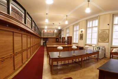 Map Collection in 2013 (Photo: M. Kowalski)
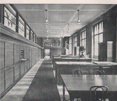 Map Collection in 1931
Document Actions