3rd Military Survey 1:25,000
The CU FS Map collection owns valuable original hand-drawn topographic sections of the Czech lands at a scale of 1:25,000 (3rd military mapping) taken over along with 30,000 documents from the 1st republic from the Vienna Archive.
The topographic section sheets are recorded in the acquisitions log, catalogued in the Map Collection catalog and can be accessed in the Digital University Repository.
Dr. Ivan Kupčík discussing topographic sections (1:25 000) in the CU FS Map Collection (in Czech)

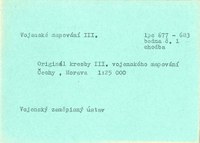
Typed list of topographic sections (1:25,000) from the card catalog of the CU FS Map Collection
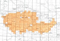
Overview of 236 original hand-drawn topographic sections (1:25,000) owned by the CU FS Map Collection
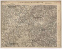
Sample of bibliography entry of a hand-drawn sheet of a topographic section in the Map Collection catalog
List of literature for original manuscripts
BOGUSZAK, František a Jan, CÍSAŘ. Mapování a měření českých zemí od poloviny 18. století do počátku 20. století. Praha: Ústřední správa geodézie a kartografie, 1961. 80 s.
KUCHAŘ, Karel. Mapové prameny ke geografii Československa. Acta Universitatis Carolinae : Geographica, 1967, roč. 2, s. 57-97. Dostupné z: http://web.natur.cuni.cz/gis/kuchar/index.php/zpravy/summary/7-clanky/155-mapove-prameny-ke-geografii-ceskoslovenska
KUCHAŘ, Karel. Naše mapy odedávna do dneška. Praha: Nakladatelství Československé akademie věd, 1958. 129 s.
KUPČÍK, Ivan. Z dějin geodézie a kartografie. Z pozůstalosti mapových originálů III. vojenského mapování. Geodetický a kartografický obzor, 1976, roč. 22, č. 5, s. 147-148. Dostupné z: http://archivnimapy.cuzk.cz/zemvest/cisla/Rok197605.pdf
KUPČÍK, Ivan. The State Map Collection in Prague. Imago Mundi. 1983, roč. 35, č. 1, s. 103-104. ISSN 0308-5694. Dostupné pro PřF UK z: http://www.tandfonline.com/doi/abs/10.1080/03085698308592560#.VWbKzv4w-mQ
MIKŠOVSKÝ, Miroslav a Bohumil ŠÍDLO. Topografické mapování našeho území ve 20. století. In: 14. kartografická konference. Úloha kartografie v geoinformační společnosti, 11. – 13. září 2001 v Plzni. Plzeň, 2001 [cit. 2015-03-17]. Dostupné z: http://gis.zcu.cz/kartografie/konference2001/sbornik/miksovsky/miksovsky_referat.htm
Document Actions