Siege map
Information about map registred to UNESCO International Memory of the World Register
An unique map of the Great Siege of Malta of 1565 Giovanni Francesco Camocio was found in the Map Collection of Charles University. Digital copy of the map is available HERE.
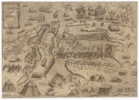 State 2 of Great Siege of Malta map
Source: The Map Collection of Faculty of Science of Charles University
The map is one of the four maps which represetn the last phases of the Great Siege of Malta, battle in port Valletta. Maps nr. 1, 3 and 4 are deposited in the National Museum of Fine Arts Valletta. Version nr. 2 was found in the Map Collection of Charles University and it is the only preserved examplar known to exist in European and American collections. The author of all four maps is an Italian Renaissance printer and publisher Giovanni Francesco Camocio. Camocio published in Venice and his printing character was a pyramid.
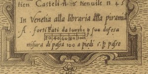 Imprint of Venice publisher
Source: The Map Collection of Faculty
of Science of Charles University
These four maps present the last phases of the Great Siege of Malta between May and September 1565. In versions of maps there are moves of Turkish armies and Christian soldiers fighting both on the ship and on the fortification. Student Jakub Báča created animation based on these maps. Video is available HERE.
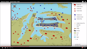 Animation of the battle
Source: Jakub Báča
Document Actions